|
As we described in a previous Modeling Tip, the Ontario Ministry of the Environment, Conservation and Parks (MECP) now distributes Canadian Digital Elevation Model (CDEM) data in GeoTIFF format via a portal on their website.
One potential issue with this new dataset is that it does not provide elevation data for neighboring parts of the United States. For projects with domains along the international border, this will cause AERMAP to input missing elevations for receptors not in Canadian territory which leads to AERMOD run failures:
******** FATAL ERROR MESSAGES ********
RE E259 48 RECARD: Receptor elevation is missing (-9999.0); IREC = 1474
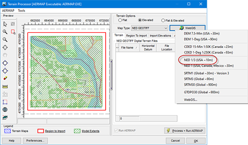
To overcome this challenge, modelers can utilize high-resolution terrain from the US – in addition to MECP’s GeoTIFF data – by accessing NED 1/3 arc-second dataset from AERMOD View’s WebGIS feature.
Follow the steps below to generate a complete terrain dataset for projects along the US-Canadian border:
Step 1: At the point where you want to import elevations, open the Terrain Processor.

Step 2: Set the Map Type drop-down menu to NED GEOTIFF.

Step 3: Press the WebGIS button and select the NED 1/3 (USA ~10m) option. Do not use the 1 arc-second (30m resolution) NED product.

NOTE: You must have a current maintenance agreement to download NED terrain data products. For pricing to upgrade your license, please contact our sales team at sales@webLakes.com.
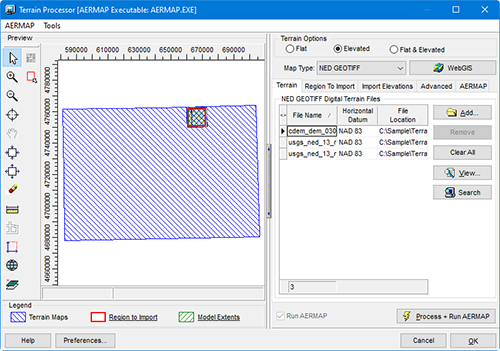
Step 4: After downloading the NED data, select the Add button and add the MECP GeoTIFF file for your project location. It is important that the NED data be added first and the MECP data after.

Step 5: Click  to execute AERMAP. to execute AERMAP.
Step 6: When AERMAP finishes, identify which objects you wish to import elevations for (sources, receptors, and/or buildings) and click Import.
This process will import elevations for the full domain using country-specific data for the relevant receptors.
|


