A major step in any CALPUFF modeling study is to calculate geophysical properties of the modeling domain. The CALPUFF modeling system contains several preprocessors to perform these calculations including:
- TERREL for processing terrain elevations from digital terrain files
- CTGCOMP & CTGPROC which compress and process digital land use data to determine the dominant land use type within each domain grid cell
- MAKEGEO reads the output from TERREL & CTGPROC to create a geophysical data file – GEO.DAT – to supply the calculated geophysical parameters to CALMET
CALPUFF View's Geophysical Processor handles processing of the geophysical data files through these programs.
One important feature within the Geo Processor is the ability to customize the land use property values MAKEGEO uses in its calculations. Follow the steps below to customize land use for your project:
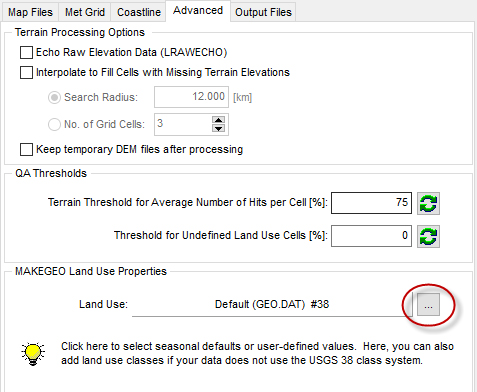
Step 1:Open the Geophysical Processor and select the Advanced tab. Look for the MAKEGEO Land Use Properties group settings at the bottom of this tab.
Step 2: Select the browse icon to open the Land Use Properties dialog.

Geo Processor Advanced Settings

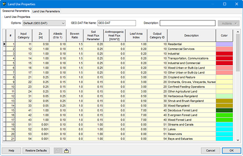
Land Use Properties Dialog with Default Seasonal Parameters
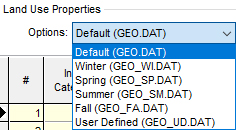
Step 3: From the Options menu, you can select season-specific parameters to be used for a given MAKEGEO run. For example, the Winter conditions (GEO_WI.DAT) assume continuous snow cover on the ground and increase the seasonal albedo for each land use category.

Seasonal Options for Land Use Properties
Step 4: Define custom parameters by selecting the User Defined (GEO_UD.DAT) option. Selecting this option will make all table values open for editing. A custom name can be defined for the data set in the GEO.DAT File Name field.

Step 5: Type in numeric values for each of the geophysical parameters in each of the 38 land use categories of the USGS system.
Parameters can be imported from an Excel spreadsheet using the Import icon at the bottom of the dialog. Alternatively, a template can be exported to an Excel template using the Export icon.

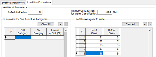
Step 6: If your categorization does not match the existing USGS 38-category system, the Land Use Parameters tab can be used to specify additional category information. In this tab, you can:
- Match up the input and output categories for the land use categories associated with water;
- Define the minimum fraction of each cell covered by water necessary for the average land use to be water-based;
- Set the number of input categories that are split by apportioning area among the other land use categories; and
- Specify what land use code to assign to a cell when no land use data are found.

Land Use Parameters Tab
Step 7: When finished, click  to exit the dialog. The MAKEGEO Land Use Properties group now indicates the custom file. to exit the dialog. The MAKEGEO Land Use Properties group now indicates the custom file.

With the custom land use properties specified, you can now input the digital terrain and land use files to the Geo Processor and process the data to create the GEO.DAT file for input to CALMET.
|


