|
AERMAP is the US EPA’s terrain preprocessor for the AERMOD modeling system. AERMAP reads digital terrain and calculates base elevations for sources and receptors and hill height scale factors for receptors. Users of AERMOD View know they can easily access digital terrain data via the WebGIS automated download feature which includes access to worldwide terrain data.
AERMOD View Version 10.2, released in December 2021, included an important update to WebGIS when downloading USGS GEOTIFF tiles from the 3D Elevation Program (formerly the National Elevation Dataset [NED]). This update ensures AERMOD View users continue to access the most up-to-date NED GEOTIFF tiles available directly from the USGS servers. NED downloads now include the full 1°x1° extents of the tile (or tiles) which cover the modeling domain.
As described in a previous Modeling Tip, AERMAP defaults to reading the full extents of the digital terrain tiles for the purpose of calculating the receptor hill height scale. For large-sized, high-resolution tiles such as the 1/3 arc-second (10-meter) resolution NED files, this can dramatically increase runtimes when executing AERMAP.
To significantly increase the speed of AERMAP runtimes, AERMOD View includes two features which can assist users.
User-Defined Domain
AERMAP runs more slowly with a large terrain tile because it analyzes all the terrain nodes when calculating the hill height scale. One way to reduce runtime is to limit the area assessed by AERMAP.
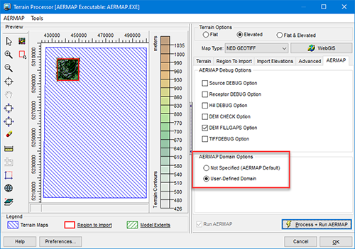
In AERMOD View’s Terrain Processor, select the AERMAP tab. Here, you will find the AERMAP Domain Options. Selecting the User-Defined Domain option will limit AERMAP’s calculations to the domain extents defined by the Region to Import tab.

AERMAP Domain Options

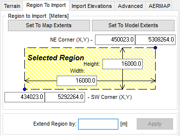
Region to Import Definition
Users can graphically define the Region to Import using the  icon in the Terrain Processor Preview window. icon in the Terrain Processor Preview window.
By utilizing the User-Defined domain, users can restrict AERMAP to assessing only the necessary area within the digital terrain file thus saving time by avoiding unnecessary calculations.
Parallel AERMAP (Lakes AERMAP MPI)
AERMOD View users are likely familiar with the parallelized AERMOD model – AERMOD MPI – that reduces model runtimes significantly. The application also includes a parallelized version of AERMAP as well!
By performing calculations in parallel, AERMAP will run on up to 8 processors thus dramatically decreasing total runtime. To use this powerful feature, complete the following steps:
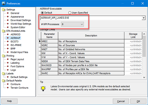
Step 1: Open the Preferences dialog by clicking File | Preferences from the menu.
Step 2: In the Preferences dialog, select EPA Models/Limits | AERMAP.
Step 3: Make sure the Default radio button is selected and choose one of the MPI executables from the drop-down list.
Step 4: Select the number of processors (up to 8) to use from the # MPI Processes menu.
With the MPI executable selected, return to the Terrain Processor and run AERMAP. AERMOD View takes care of the rest!

|
