Compliance Corner: Navigating the Regulatory Realm |
|
Planned Updates to the US EPA AERMOD Modeling System (Version 24142)
The U.S. Environmental Protection Agency (EPA) is preparing to release an updated version of the AERMOD Modeling System, scheduled to be dated as version 24142. AERMOD is the EPA’s preferred dispersion modeling system used to estimate pollutant concentrations from industrial sources and is a key tool in air quality assessments and regulatory compliance.
This update will include several important enhancements to AERMOD and related processing programs AERMET, AERMAP, and AERSURFACE. Key improvements include important enhancements and fixes that improve model usability and accuracy. These changes aim to provide more precise assessments of potential air quality impacts, aligning with the EPA's commitment to using the latest science and technology.
Stakeholders are encouraged to review the forthcoming updates and ensure compliance with any new requirements for regulatory submissions. Detailed documentation and training materials will be available once the new version is released.
Stay tuned for more information from the EPA as version 24142 becomes available.
For those not currently using AERMOD View, our popular graphical user interface for the AERMOD model, now is the ideal time to consider investing in this industry-leading software. AERMOD View offers an intuitive interface and powerful features, making it easier to implement the latest updates and maintain compliance with EPA standards.
Contact us today to learn more about purchasing AERMOD View and ensuring your air quality assessments are both accurate and efficient!
|
|
Online AERMOD Training Course – Nov 5-6, 2024 - Filling Fast! |
 |
Don’t miss out on our next available 2-day online AERMOD training course taking place on November 5 and 6, 2024, from 8:30am to 5:00pm (Central Time – Chicago, USA).
Register today before space is gone!
Note: Due to the immense popularity of our online courses and small class sizes, we recommend registering and making payment as soon as possible to reserve your spot.
|
|
Just Announced – New Online AERMOD and CALPUFF Courses! |
 |
We’re pleased to announce the following upcoming Online AERMOD and CALPUFF Air Dispersion Modeling Courses. Join us for world class training from the convenience of your own home or office with our senior level air quality experts!
Online registration will open soon. Secure your spot early—register and pay before these courses fill up!
|
|
Lakes Environmental Closed for Canadian Thanksgiving Holiday |
Lakes Environmental's offices will be closed on Monday, October 14, 2024, to observe the Canadian Thanksgiving holiday. Our Dallas office will remain open on this day. If you have any needs during that time, please e-mail us support@webLakes.com. and we will respond to your inquiry as soon as possible.
|
|
UPCOMING TRAINING COURSES |
|

|
MODELING TIP |
Custom Terrain Data in AERMOD View |
|
AERMAP is the terrain preprocessor program for incorporating terrain elements into air dispersion modeling analyses conducted using the AERMOD dispersion modeling system. Natively, AERMAP reads two types of terrain data:
- United States Geological Survey (USGS) National Elevation Dataset (NED) files in GeoTIFF image format
- USGS Digital Elevation Model (DEM) tiles in ASCII format
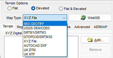
Because these formats are primarily regionalized to cover the United States, Lakes Software has added support for several other terrain file formats so that global users have multiple options for processing elevations. Coupled with the WebGIS automated data download feature, AERMOD View users have access to free, high-resolution data regardless of their location.

AERMOD View’s List of Supported Terrain File Formats
One unique terrain file format supported by AERMOD View is a simple XYZ File. This file format provides users the opportunity to import custom elevations that would be otherwise difficult to incorporate into the model. This could include areas where elevations have been modified or are not adequately represented using other formats due to recent changes.
Below are a few tips and instructions on the use of XYZ files in the Terrain Processor.
XYZ Formatting
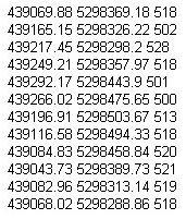
XYZ files can be comma or space delimited, and they should be organized in Column and Row format.
- The first column must contain the X coordinate of the point.
- The second column must contain the Y coordinate of the point.
- The third column must contain the terrain elevation for the specified location.
- Each row must contain only one point.
- Units can be meters or kilometers.
When using XYZ files, note that the file must cover the entire extents to be processed with AERMAP.

Sample XYZ Data
Using XYZ Files
Once the XYZ file is generated, using the file in AERMOD View is very simple.
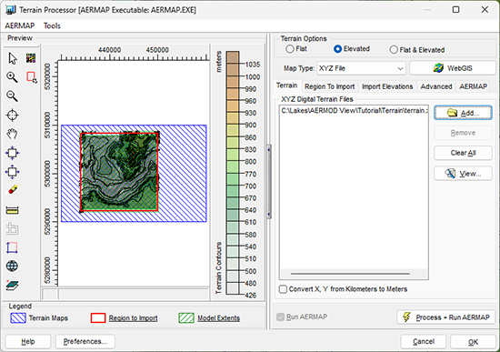
- Open the Terrain Processor
- Select XYZ File as the Map Type
- Click the Add button and select the XYZ file
- Select any other relevant options for executing AERMAP
- Click the Process + Run AERMAP button to execute

Sample XYZ File in AERMOD View’s Terrain Processor
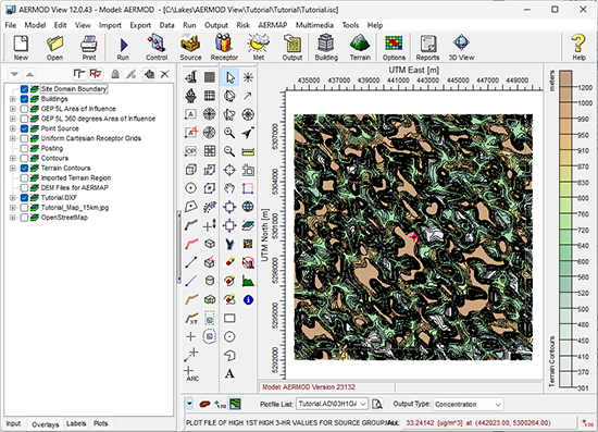
Upon successful completion of AERMAP, the Terrain Contours will be shown in the main display of the application.

|
|

|
ENVIRONMENTAL NEWS ARTICLES |
Extreme Weather to Strengthen Rapidly Over Next Two Decades |
September 9, 2024 - Nearly three quarters of the global population can expect strong and rapid changes in extreme temperatures and rainfall in the next 20 years unless greenhouse gas emissions are cut dramatically, according to a new study.
Read more → |
|
Study Shows Sea-Level Rise for Future Generations Is Highly Dependent on Emission Levels |
September 12, 2024 - A multi-institutional study, led by Dartmouth Engineering Professor Hélène Seroussi, extends scientists' predictions of how greenhouse gas emissions will likely affect sea-level rise beyond the twenty-first century. Published in Earth's Future, the study is the first to combine data from 16 different ice sheet models and shows that, with continued high emissions, Antarctic's contribution to sea-level rise increases rapidly from 2100 to 2300.
Read more → |
|
|
|
UPCOMING CONFERENCES |
2024 Conference Schedule |
|
AWMA Specialty Conference – Guideline on Air Quality Models: A New Chapter
November 13-15, 2024 | Raleigh, NC
Learn more →
|
|
|
LAKES SOFTWARE GROUP OF COMPANIES
|
 |
1-170 Columbia St. W.
Waterloo, ON N2L 3L3
View Online
This newsletter contains information gleaned from various sources on the web, with complete links
to the sources cited. Organizations cited are in no way affiliated with Lakes Environmental Software.
For more information, please visit our web site at: www.webLakes.com.
All comments and suggestions are welcome. You can e-mail us at: support@webLakes.com.
Privacy Policy |
|
| | |
